Road planning, the visual way
Back in 1992, digital visualisation wasn’t something you’d typically find in road planning. There was no Google Maps to lean on, and while 3D rendering technically existed, it wasn’t something most infrastructure projects made use of. Planning was still very much a world of thick reports, technical drawings and a fair bit of imagination.
Vejdirektoratet wanted to try a different approach. They were planning a new motorway and needed a way to help people understand how it would actually take shape in the real world.
In this Insight, we'll take you back to where our story with visualising road planning started. It's a long one, and lasted many years. Therefore, you'll se visuals from all the different years. Just promise to hang on tight, this is a good story.


A road to see the infrastructure
The task was simple in theory, but not in practice. Visualise a road that didn’t exist yet, in a landscape that very much did. Working with aerial photography from survey flights, GPS data and reference models from Kampsax, we began piecing together the full picture.
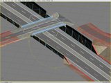
Using early tools like 3D Studio, we created a digital representation of the planned motorway. It included terrain, vegetation, alignment and all the small visual cues that help people relate to what they’re seeing.
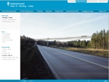
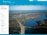
We also made an interactive presentation where you could explore the route from different viewpoints and click through simple hotspots for more detail. It sounds standard now, but back then it was something quite new.


Then and now
Instead of handing over a technical folder and expecting people to read their way through it, we created something they could look at, explore and understand without needing to be an engineer.
Today we’re still working with interactive 3D, simulations and visual tools to explain and explore complex ideas. The tech has moved a bit, sure, but more than anything, we’ve refined our approach and gotten even better at what we do.
Looking at that early interactive presentation, it’s striking how familiar it still feels. The interface, the hotspots, the layers are all part of how we work today. The motorway project might belong to the early days, but the mindset behind it is still very much alive.
Curious to see where the road leads next?
We promise not to bring our 90s computers.
Related Insights


